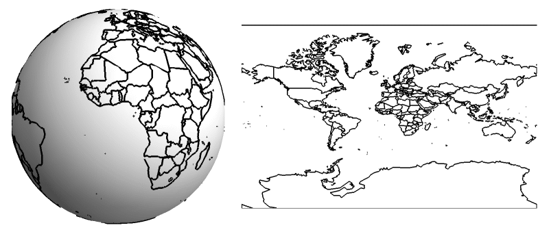
Projecting a sphere on a surface can only be done at the price of some distortion. Mercator’s projection is very useful if you are sailing, but strongly distorts sizes. And if we can change what is at the centre of the map we can see how much.
I am planning to release all the animated GIFs I create to illustrate the #Physicsfactlet in the public domain, and upload them on @WikiCommons in the unlikely case anyone has an use for them. Where relevant I will also add the script used to create them.
— Jacopo Bertolotti (@j_bertolotti) August 17, 2018
A tweet about the recently had some great comments…
There are many ways to get across the point of distortion in the Mercator map. Here's a planisphere indicating a distance across Africa and another distance across Russia and things don't add up [source, read more: https://t.co/O3oZ1beSF2] pic.twitter.com/mYHUQhW6dm
— Massimo (@Rainmaker1973) August 20, 2022
This is a great tool to compare the sizes of different countries…
This tool is good for demonstrations too: https://t.co/M71zREymqV
— Jack Shergold (@JackDShergold) August 21, 2022
A GIF showing countries scaled down to their actual size…
A friend asked me to reshare this wonderful animation by @neilrkaye. A beautifully simple yet novel way of visualizing the distortion of country size that Mercator projections bring with them. Love it! Source: https://t.co/00WD7tMOud pic.twitter.com/yt0sCP56uw
— Simon Kuestenmacher (@simongerman600) October 22, 2020
Another cool map tool that is open-source…
Countries scaled around their centres to right relative sizes, but overall square they're rendered on still more zoomed in further from equator, hence the gaps.
Mercator is conformal (angles are correct) but scale varies with latitude to achieve this.https://t.co/NdpUcZjt6r
— TimPBristol (@TimPBristol) October 22, 2020

0 Comments