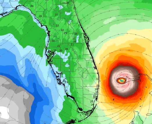
Most recent model prediction…
Most recent GFS Model Run of #HurricaneDorian
Details on @winknews pic.twitter.com/1teE1KaiYo
— FOX Sports Radio | SWFL (@FOXSportsSWFL) September 1, 2019
Wider view of Hurricane #Dorian as it continues its devastating trek across the northern Bahamas. pic.twitter.com/5oNvVK4kDm
— Dayna Vettese (@daynavettese) September 1, 2019
As #HurricaneDorian approached the #AbacoIslands, NOAA's #GOESEast zoomed in on the powerful storm's eye. The Cat. 5 storm's "maximum winds have increased to near 175 mph with gusts over 200 mph," according to @NHC_Atlantic. Follow the storm: https://t.co/VDEWvXtPxt pic.twitter.com/wLnZjJJYMO
— NOAA Satellites (@NOAASatellites) September 1, 2019
🛰️ Satellite imagery this morning of now Category 5 Hurricane Dorian approaching the Abaco Islands in the northern Bahamas. For the latest on Dorian visit https://t.co/ONza7RQRVp pic.twitter.com/GJRAKhr7jA
— NWS Austin/San Antonio (@NWSSanAntonio) September 1, 2019
NHC 11am
: DORIAN BECOMES THE STRONGEST HURRICANE IN MODERN RECORDS FOR
THE NORTHWESTERN BAHAMAS….913mb
180mph winds
moving w at 7mph pic.twitter.com/VY4ziKv2An— Jim Cantore (@JimCantore) September 1, 2019
JUST IN: Hurricane Dorian has become the "strongest hurricane in modern records" for the northwestern Bahamas.
-Winds up to 180 mph
-Moving W at 7 mph
-20 miles ENE of Great Abaco Islandhttps://t.co/7GAEhuUIU0 pic.twitter.com/xRw6mxrCGG— World News Tonight (@ABCWorldNews) September 1, 2019
The short term forecast for Hurricane #Dorian is definitely concerning.
The center will likely remain offshore but the margin for error is only 10s of miles between major hurricane conditions vs. not.
(ECMWF 06z model — @weathermodels_ ) pic.twitter.com/3Hu3mzhA0O
— Ryan Maue (@RyanMaue) September 1, 2019
Updating every 60 seconds at 500 meter resolution, GOES-East was able to view Hurricane #Dorian as it made landfall in the Bahamas.
Notice the outer cays and shallow water adjacent to Great Abaco Island within a relatively clear eye. pic.twitter.com/yS4SgIRzA6
— NWS Grand Forks (@NWSGrandForks) September 1, 2019
NOAA's #GOESEast spotted lightning in the eye of #HurricaneDorian this morning. The now catastrophic Cat. 5 storm is expected to bring life-threatening storm surge and very heavy rainfall to the Abaco Islands and Grand Bahama through Monday. More: https://t.co/hGBv8RfDYM pic.twitter.com/dDxjoQjoJD
— NOAA Satellites (@NOAASatellites) September 1, 2019
#Dorian made landfall at Elbow Cay in The Bahamas with wind speeds of 185 mph. It is now tied as the second strongest Atlantic hurricane on record. pic.twitter.com/UemkALsivx
— The Weather Channel (@weatherchannel) September 1, 2019


0 Comments